Happy Summer to all of you!!!
Let's do it again next year.
Cheers, Patty
April 17, 2010
April 16, 2010
SPOT WEATHER FORECAST
4/16/2010 Weather
Short term: Today will be mainly dry with a chance of a rain shower later this afternoon. It will be possible to experience the warmest day of the year, so far.
Long-term: The chance of rain showers will continue through the weekend. Next week will start out wet and cooler with drying for the second half. Temps will be around normal for this time of the year.
24 hour Forecast Starting at NOON on Friday
Precipitation
“ Water: .10
“ of Snow: 0
Temperatures (F):
4000’ Low: 34 High: 50
5000’ Low: 32 High: 48
Winds speed/Direction
Pass level: 0-5 E
Ridge top: 0-10 E
TRENDS AND TIMING
Precipitation: Building cumulus clouds will bring a threat of rain showers this afternoon. Warm air will aid in vertical uplift, so could hear some thunder rumbling out there.
Freezing levels: 7000-8000’. Freezing levels will lower some tomorrow but remain above pass level through the weekend.
Winds: Light east flow will continue today and then shift SSW tomorrow. JDM
April 15, 2010
SPOT WEATHER FORECAST
4/15/2010 Weather
Short term: A band of rain will move through today. Drying tonight.
Long-term: Friday will be mainly dry with another chance of rain showers through the weekend.
24 hour Forecast Starting at NOON on Thursday
Precipitation
“ Water: lt.25
“ of Snow: 0
Temperatures (F):
4000’ Low: 32 High: 50
5000’ Low: 30 High: 48
Winds speed/Direction
Pass level: 0-5 E
Ridge top: 0-5 E
TRENDS AND TIMING
Precipitation: Rain will be possible after noon today. Things will quickly dry up tonight with a dry day tomorrow.
Freezing levels: 6000’-8000’. Freezing levels will rise above 8000 tonight. Freezing levels will remain high until Saturday morning. Surface temps could touch the 50’s today and tomorrow. Clearing tonight might allow lows to reach the freezing mark.
Winds: Light east/offshore flow will continue through tomorrow. JDM
April 14, 2010
April 11, 2010
SPOT WEATHER FORECAST
4/11/2010 Weather
Short term: A low pressure system hitting the California coast will continue to spin light bands of moisture up through the PNW today and tomorrow.
Long-term: This typical early spring pattern will continue through most of the week. Temperatures will also be normal with freezing levels rising above 6000’ by the end of the week.
24 hour Forecast Starting at NOON on Sunday
Precipitation
“ Water: .10
“ of Snow: trace
Temperatures (F):
4000’ Low: 30 High: 40
5000’ Low: 28 High: 38
Winds speed/Direction
Pass level: 5-10 E
Ridge top: 5-10 E
TRENDS AND TIMING
Precipitation: Light snow/rain showers will be possible for the next 24 hours.
Freezing levels: 4000-5000’. Freezing levels will creep up today and continue to slowly rise through the week. It will be possible to see 7-8k freezing levels by the end of the week.
Winds: Gusty East flow will continue through the tomorrow. JDM
April 10, 2010
SPOT WEATHER FORECAST
4/10/2010 Weather
Short term: Today will be dry with just high clouds.
Long-term: A low pressure system off the coast of California will spin weak systems up through the PNW starting tomorrow. Could get some very light rain/snow mix tomorrow and again on Monday.
24 hour Forecast Starting at NOON on Saturday
Precipitation
“ Water: lt .10
“ of Snow: 0
Temperatures (F):
4000’ Low: 24 High: 34
5000’ Low: 22 High: 30
Winds speed/Direction
Pass level: 5-10 E
Ridge top: 5-15 E brisk
TRENDS AND TIMING
Precipitation: No precipitation expected today. Some light rain, snow mix will be possible around mid day tomorrow.
Freezing levels: 3500-4500’. Warmer air moves in from the SE today. Seasonal norm freezing levels will settle in this week with averages at or above 4000’.
Winds: Strengthening east flow will develop today -could get gust above 20mph from time to time. JDM
April 9, 2010
SPOT WEATHER FORECAST
4/9/2010 Weather
Short term: A high pressure ridge developing today will bring an end to the snow.
Long-term: The weekend will be dryer and warmer. Some weak systems will move through late Sunday, but for the most part, not expecting any significant weather events for the week. The overall pattern seems to be changing in response to the changing season.
24 hour Forecast Starting at NOON on Friday
Precipitation
“ Water: .10
“ of Snow: trace -1
Temperatures (F):
4000’ Low: 18 High: 32
5000’ Low: 16 High: 30
Winds speed/Direction
Pass level: 0-10 E
Ridge top: 5-15 E
TRENDS AND TIMING
Precipitation: A few snow showers will linger for the rest of the day. Dry after 4pm today.
Freezing levels: 2500-3500’. Freezing levels will remain relatively low through the night with surface lows in the high teens. Freezing levels will rise to 4000’ with the sun pushing surface temps above freezing tomorrow afternoon. Temperature will return to seasonal norms next week.
Winds: The winds should also be tapering off through the day. East flow will develop overnight and strengthen during the day. JDM
April 8, 2010
SPOT WEATHER FORECAST
4/8/2010 Weather
Short term: Snow showers and blustery conditions will continue today.
Long-term: High pressure will begin to build over the inland NW tomorrow night. This will bring a dry and party sunny weekend. Next week looks to be mainly dry with some weak systems moving through late Monday/Tuesday.
24 hour Forecast Starting at NOON on Thursday
Precipitation
“ Water: .5-.75
“ of Snow: 6-10
Temperatures (F):
4000’ Low: 18 High: 26
5000’ Low: 18 High: 24
Winds speed/Direction
Pass level: 5-10 W
Ridge top: 10-20 W gusty
TRENDS AND TIMING
Precipitation: Moderate snow showers will continue through noon tomorrow. Snow will begin to taper off tomorrow afternoon and then be done all together by Saturday morning.
Freezing levels: 1000’-2000’. Freezing levels will continue to be low through the night. Freezing levels are expected to rise to pass level on Saturday.
Winds: Blustery west winds will continue through the day/night. East flow develops on Saturday. JDM
April 7, 2010

SPOT WEATHER FORECAST
4/7/2010 Weather
Short term: Here we go again. A strong cold front approaching the coast will bring another round of wind and snow tonight and tomorrow.
Long-term: Snow will taper off late Friday with a dry, partly sunny weekend ahead.
24 hour Forecast Starting at NOON on Wednesday
Precipitation
“ Water: .5-.75
“ of Snow: 6-10
Temperatures (F):
4000’ Low: 22 High: 34
5000’ Low: 20 High: 30
Winds speed/Direction
Pass level: 0-5 SW – shift W becoming strong
Ridge top: 5-10 WSW - “ “ “
TRENDS AND TIMING
Precipitation: Snow will ramp up tonight and continue through tomorrow. Should have .5” by 4am and then and another .25 or more by noon tomorrow. Storm totals by Saturday morning are currently above +2” of water (2’of snow)
Freezing levels: 4000’-3000’ Freezing levels will hover near pass level for the rest of the day. Freezing levels will then drop to 2000’ or lower as the front moves through tomorrow morning.
Winds: Light SW flow will continue today. A strong westerly wind event will accompany the front early tomorrow morning. Could see initial gust above 40mph with sustained westerlies in the 20’s through tomorrow. JDM
April 6, 2010

SPOT WEATHER FORECAST
4/6/2010 Weather
Short term: Snow with occasional breaks will continue through tomorrow.
Long-term: A strong cold front will bring moderate to heavy snow to the mountains on Thursday/Friday. A weak high pressure ridge will try and build over the weekend. So for now, the weekend continues to look dry.
24 hour Forecast Starting at NOON on Tuesday
Precipitation
“ Water: .5
“ of Snow: 4-6
Temperatures (F):
4000’ Low: 24 High: 32
5000’ Low: 22 High: 30
Winds speed/Direction
Pass level: 5-10 W
Ridge top: 5-15 W
TRENDS AND TIMING
Precipitation: A weak convergence has developed today. This will keep it snowing in the mountains through the day/night.
Freezing levels: 3000’-4000’. Freezing levels will rise to 4000’ as southwest flow brings in some warmer air tomorrow.
Winds: Westerly convergence flow will continue through the day. SW flow will arrive tomorrow. JDM
April 5, 2010
SPOT WEATHER FORECAST
THE POW MACHINE CONTIUES.
4/5/2010 Weather
Short term: The snow will taper off this afternoon. More of the same tonight, snow showers through the night.
Long-term: Looks like the snow machine will continue through the meat of the week. Friday- Sunday looks to be dry at this point.
24 hour Forecast Starting at NOON on Monday
Precipitation
“ Water: .25+
“ of Snow: 3-5
Temperatures (F):
4000’ Low: 22 High: 34
5000’ Low: 20 High: 30
Winds speed/Direction
Pass level: 0-5 SSE shifting W
Ridge top: 5-10 SW
TRENDS AND TIMING
Precipitation: Radar has the trailing edge of this band of snow north if I90 as of 8am this morning, so expect the snow to come to an end soon. More snow showers tonight and tomorrow.
Freezing levels: 3500’-4000’. Freezing levels will drop early tomorrow morning when a weak cold front moves through.
Winds: Winds will be sporadic through the next 12 hours. Breezy westerly flow will take over sometime through the night. Expect gusty westerlies through the day tomorrow. JDM
April 4, 2010
SPOT WEATHER FORECAST
4/4/2010 Weather
Short term: Sun breaks today with a chance of snow early tomorrow morning.
Long-term: The northern jet stream is still positioned to continue this cool NW weather pattern. This will keep the chance of some snow every day this week, with a bigger dose on Wed/Thursday. Should be great skiing all week.
24 hour Forecast Starting at NOON on Sunday
Precipitation
“ Water: .25
“ of Snow: 1-3
Temperatures (F):
4000’ Low: 22 High: 36
5000’ Low: 20 High: 32
Winds speed/Direction
Pass level: 5-10 E
Ridge top: 5-15 E gusty
TRENDS AND TIMING
Precipitation: Very light snow shower with sun breaks will be on the menu today. A band of moisture will move through early tomorrow morning, possible producing a few inches of snow.
Freezing levels: 3000’-4000’. Freezing levels will inch up to pass level today. That, with the aid of the sun, could push surface temps in the high 30’s today.
Winds: Breezy E winds will blow through the pass for the next 12 hours. A SW/ W swing will start tomorrow. JDM
April 3, 2010
SPOT WEATHER FORECAST
4/3/2010 Weather
Short term: Whew, what a storm - now for the dig out. Snow will taper to showers today with sun breaks.
Long-term: The atmosphere will remain unstable through the weekend which will allow bands of snow to pass through from time to time. This will most likely be the pattern through most of next week as cool NW flow continues.
24 hour Forecast Starting at NOON on Saturday
Precipitation
“ Water: .25
“ of Snow: 2-4
Temperatures (F):
4000’ Low: 22 High: 30
5000’ Low: 20 High: 28
Winds speed/Direction
Pass level: 0-5 SE shifting E
Ridge top: 5-10 SE Shifting E
TRENDS AND TIMING
Precipitation: The main push of moisture is over. Radar is currently just showing showers lingering in the Convergence Zone. Partly cloudy conditions with snow showers will continue through tomorrow.
Freezing levels: 3000’. Freezing levels will remain below pass level. Sun break could push surface temperatures near freezing.
Winds: The winds will soon taper and shift southerly this afternoon. East flow will develop overnight and could become breezy tomorrow. JDM
April 2, 2010

SPOT WEATHER FORECAST
4/2/2010 Weather
Short term: Well it’s here, the big April dump. This storm has everything, high winds, Puget Sound convergence, lots of moisture and low temperatures. Sporty.
Long-term: Snow will begin to taper off tomorrow afternoon. A weak high pressure ridge will try and build on Sunday. This will allow a drying trend to develop for the start of the week. The next potential for anything of interest will be Wednesday or even Thursday.
24 hour Forecast Starting at NOON on Friday
Precipitation
“ Water:.75-1
“ of Snow: 10-14”
Temperatures (F):
4000’ Low: 22 High: 28
5000’ Low: 20 High: 26
Winds speed/Direction
Pass level: 5-15 W
Ridge top: 10-20 W gust to 40 possible
TRENDS AND TIMING
Precipitation: Snow will continue through the next 24hours with the heaviest period after midnight tonight. Snow will begin to change to showers around noon tomorrow.
Freezing levels: 2000’-3000’ Freezing levels will continue to slowly fall as cooler air from the NW fills in behind the front.
Winds: This east flow will quickly shift westerly after 2pm today. A high wind advisory is in effect for most of the state. It will be possible to get sustained winds of +40mph pushing through the pass. The good news is that this will be tonight. Winds should taper off by mid morning. JDM
April 1, 2010
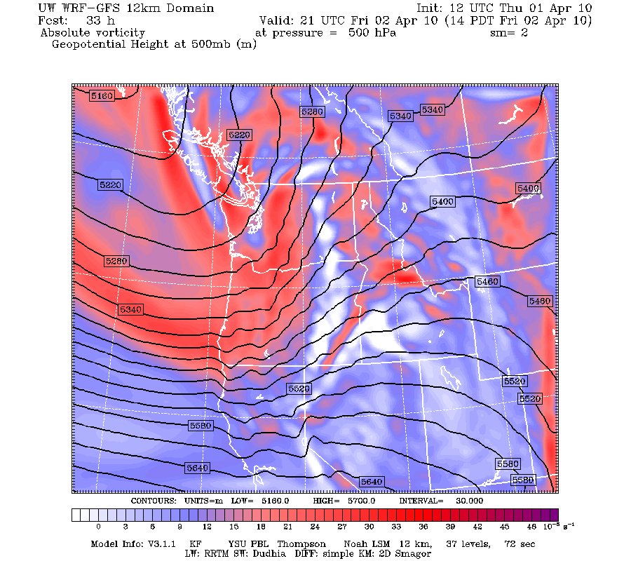
VORTICITY MODEL FOR TOMORROW
Vorticity is a measurment of how much energy a system has - you can see that the main energy is tracking south into Oregon. But still, pretty good for this time of year.

SPOT WEATHER FORECAST
4/1/2010 Weather
Short term: Clouds will thicken and some light snow showers will develop this afternoon. A strong cold front will bring heavy snow and wind tomorrow.
Long-term: This storm should be over late Saturday. Sunday/Monday looks relatively dry, similar to the last few days. NW flow will bring another potential snow producer on Tuesday.
24 hour Forecast Starting at NOON on Thursday
Precipitation
“ Water: .25-.5
“ of Snow: 4-6
Temperatures (F):
4000’ Low: 24 High: 32
5000’ Low: 22 High: 30
Winds speed/Direction
Pass level: 0-5 W shifting E
Ridge top: 0-10 W shifting E
TRENDS AND TIMING
Precipitation: Light snow showers will persist through the night. The main push of moisture will arrive after 4am tomorrow. Moderate to heavy snow with convergence will develop tomorrow. Storm totals by Saturday morning are currently exceeding 2” of water. We will see.
Freezing levels: 2000’-3000’. Freezing levels will remain in our favor through Saturday. Could see freezing levels as low as a 1000’ early Saturday morning.
Winds: Light westerly flow will briefly swing east tomorrow morning as the front moves east of the Sound. Strong westerly convergence winds will push through the pass tomorrow afternoon with the potential of sustained 40+mph winds through the night. Winds should taper and shift southerly early Saturday morning. JDM
Subscribe to:
Posts (Atom)
